

10°C
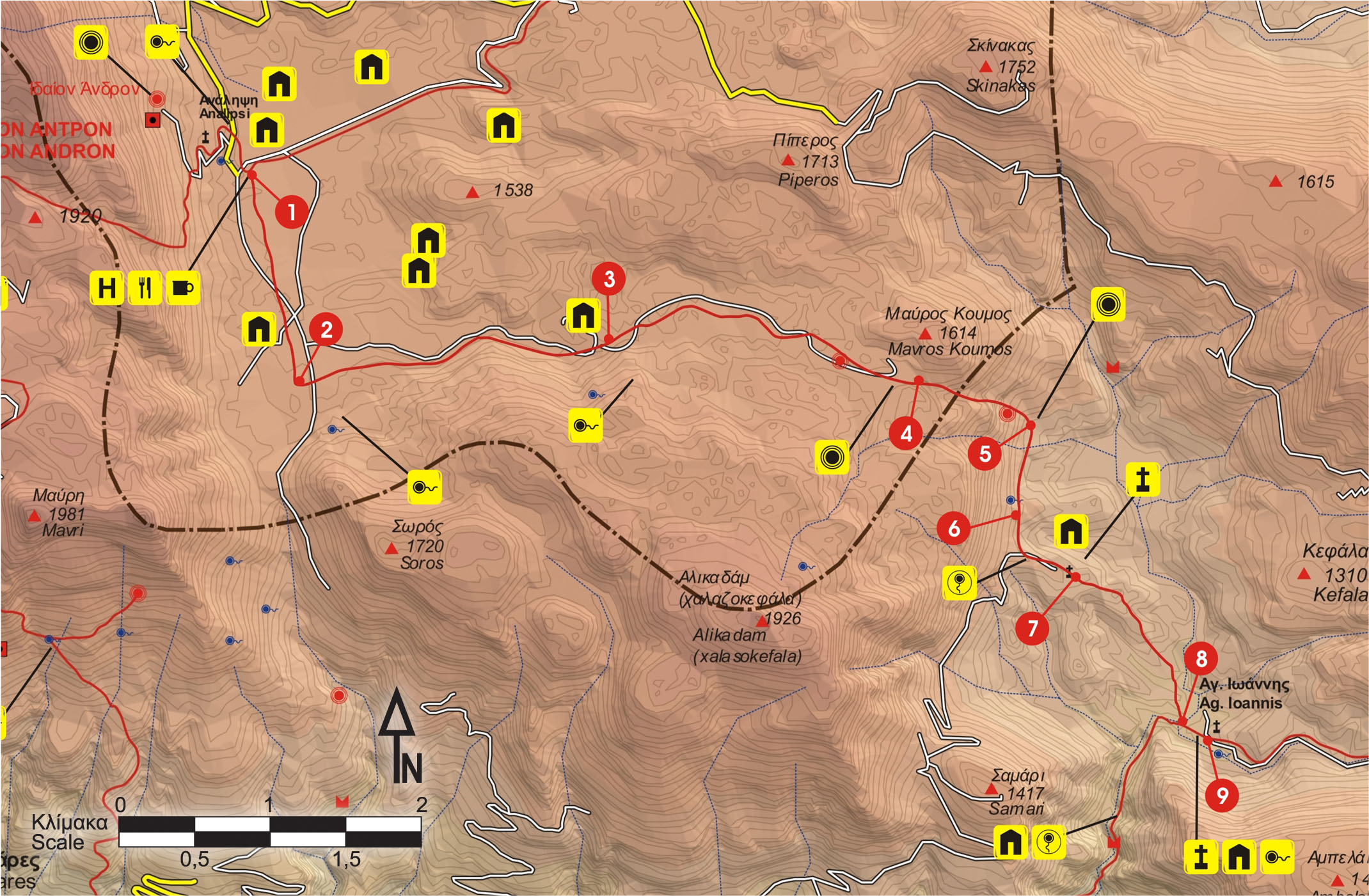
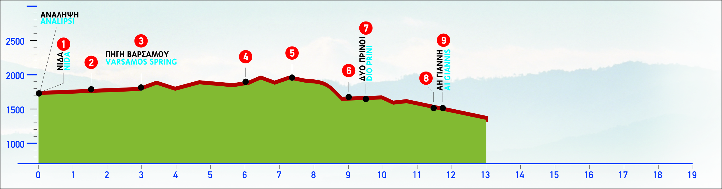
From the water spring of Analipsi, we descend to the main dirt road, which goes along the western side of the plateau of Nida and heads southwards, towards Poros tis Milias. We follow it for approximately 1.600 m, covering a big part of the plateau, until we come to a side road with an easterly direction, on our left side, which leads us to the valley of Varsamos.
We continue for about 2,2 km, until we get deep into the valley and reach a point where the unsurfaced road branches off.
The left branch after 250 m leads us to a low peak; a mitato, which can be used as a shelter, is to be found there. If we go southwards, straight up the slope from the point where the dirt road branches off and there are a lone tree and a small rock, after 200 m along the foot of the cut of the rock, we shall reach the water spring of Varsamos.
From the point where the road branches off, we continue eastwards for approximately 2 km, until we reach the end of the dirt road, at a flat area named Ammoudara, at an altitude of 1.450 m.
At the beginning of this flat area, on the right-hand -east- rock wall, a huge cave can be seen
We continue walking gently uphill towards the east, until we reach a saddle.
We then begin to descend, following the bed of a dry water course through a small gorge, among tall vegetation. After approximately 900 m, we see a big cave-like hollow, high up on our right side, at the foot of a rocky slope. By now, the forest of Rouvas opens up ahead of us.
From this point on, the E4 signs on the tree trunks and the red marks on the rocks lead us south, following the contour of 1.150 m for about 900 m.
Getting out of the area of tall vegetation is quite tricky, because it makes our orientation difficult; that is why we must be rather cautious.
Having passed by the top of a small ridge, we see a cement cistern ahead of us, at an altitude of about 1.150 m; 150 m after the cistern, a dirt road leads us to the area of Dio Prini (= two oaks), where a brick building can be seen. A little further down, in a small flat area, we come to a chapel of Michail Archangelos.
From this spot, we have a panoramic view of the whole Rouvas basin, which is bordered by a range of high peaks: Samari (1.413 m) and Ambelakia (1.441 m) to the south, between which is the gorge of Agios Nikolaos; Gyristi (1.779 m) and Koudouni (1.860 m) to the east; Skinakas (1.752 m) to the north.
From the flat area with the chapel, we follow the south-eastern clayey ridge, on a hardly discernible footpath, and constantly descend for 1.500 m, to the water course.
A few metres more to the east, the confluence of the main stream of Rouvas and of a small stream with water from the spring of Agios Ioannis can be seen. This water, during the dry, summer months,dries out a little further down, at the beginning of the gorge.
We follow the water course, and in a few minutes we reach the area of Agios Ioannis, where a designated rest area with a few plane trees can be seen next to the water course.
Close by are the chapel of Agios Ioannis and a stone building next to it, which can be used as a shelter
E4 (Yellow/Black)
3 hours
11500m
From March to October
For the Rural Greece accessibility is fundamental to enhancing an inclusive tourism experience. Following the principles of inclusion and equality, the epaithros Rural Tourism Network and its member businesses are constantly working to enhance the tourism services provided, ensuring that all visitors have the opportunity to experience the authentic beauty of the Greek countryside.
Sustainability in tourism refers to a way of developing tourism that respects and protects the environment while strengthening the local economy and preserving cultural traditions. The aim of sustainable tourism is to provide unique and authentic experiences for visitors without harming the natural and social environment, while ensuring that local communities benefit from tourism activity.
This type of tourism is based on three pillars:
With sustainable tourism, visitors can have authentic experiences, knowing that the impact of tourism on the region is positive and lasting for future generations.
For Rural Greece, localism is one of the most important factors for the development of sustainable tourism, as it promotes a strong link between the tourism product and the local society, economy and culture. Through localism, visitors get the opportunity to explore authentic elements of the destination, such as local products, traditions and culture. This not only boosts the local economy, but also helps to sustain and strengthen local businesses, creating new jobs and supporting the development of local communities.
Furthermore, localism contributes to the sustainability of the tourism sector, as it reduces the use of resources from other regions and encourages the use of local goods and services, reducing the ecological footprint of tourism activities. Thus, integrating localism into tourism practices enhances sustainability awareness, both among visitors and local businesses, creating a more responsible and sustainable tourism destination.