
7°C
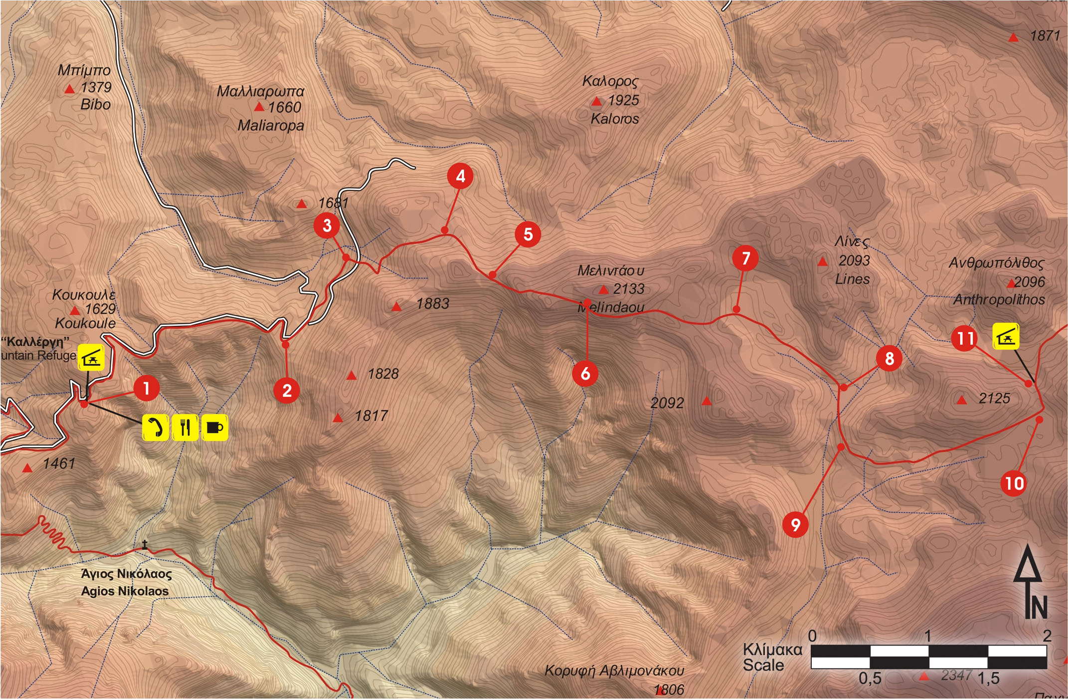
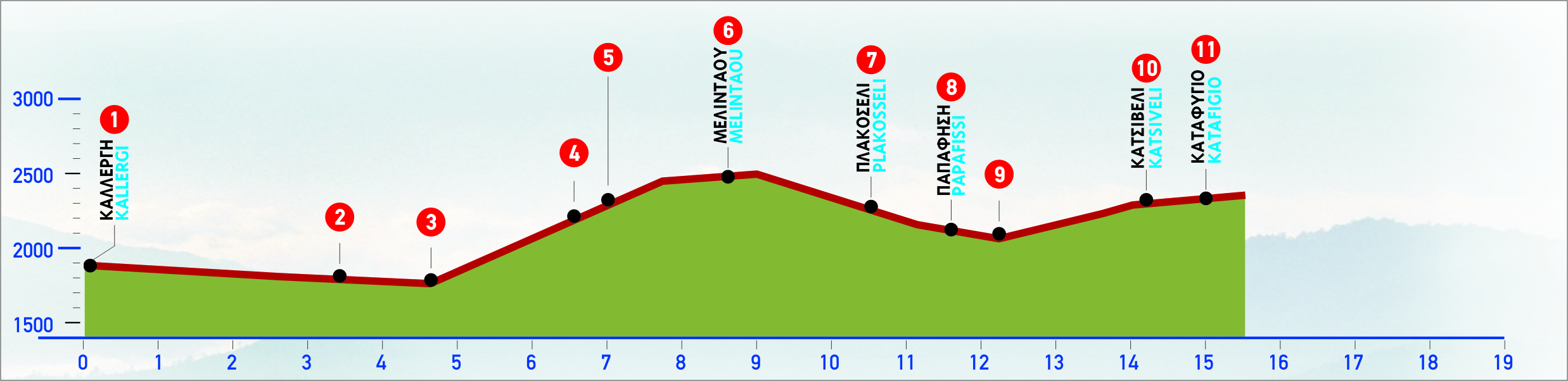
From the shelter, we follow a dirt road which winds on the northern side of lower summits, in an easterly direction. After approximately 45 minutes, we reach a small flat area where there is a sign of the Forestry Authority.
From this point, if we continue a little further to the right, onto a small saddle, where a small ruined stone shepherd’s hut is, we shall enjoy the magnificent view of the gorge of Samaria and of Gigilos.
From the small flat area, we continue on the unsurfaced road. We ignore a left branch of the road and continue on the right one, in an easterly direction. In about 800 m, on our right-hand side, we come to the beginning of a path, approximately 50 m before a small dry water course.
At this point, we are at an altitude of 1.450 m.
The path follows the right-hand (southern) side of the small water course. After 10 minutes of climb, the water course splits into two branches; we cross both beds and get to the northern side. We then ascend towards a little saddle ahead of us; as soon as we get to the top (about 45 minutes from the dirt road), we reach a small plateau with a ruined stone hut and a sheepfold, at the altitude of 1.750 m.
The area is bleak and bare, with sparse low bushes.
From the small plateau, we climb for about 20 minutes and, arriving at the ridge (at an altitude of 1.900 m) we see the peak of Melidaou, ahead in the distance. We walk along the ridge and reach the mountain line, which we then follow in an easterly direction, climbing up towards Melidaou.
The basin of the gorge of Samaria opens up now in all its grandeur, down below to our right.
We follow the distinct path towards the peak of Melidaou, until the altitude of 2.050 m approximately, to a point between the peak and the steep, rocky right-hand slope.
The slope offers an exquisite view to the south. Here, when the snow melts away, one can spot small Cretan alpine flowers, such as the crocus depicted on Minoan murals.
We leave the mountain line, pass cautiously over a steep rocky area and continue on the path which by now follows the southern slope of Melidaou. The path descends in an easterly direction to a small flat area at Plakoseli, at an altitude of 1.850 m.
Attention! The well water in the flat area is not drinkable.
To our left-hand side now the peak of Lines appears, on which rock cairns that resemble human forms can be distinguished. After a hike of 900 m in a bare ravine, in a south-easterly direction, we arrive at another flat area, of a triangular shape, south of the peak of Linés, at Papasifis. In the small flat area, which is full of low prickly bushes, there is a cistern for rain water (not drinkable). At its north-eastern edge, the stone shepherd’s dairy hut (“mitàto”) of Papasifis can be seen, where we can take shelter if we need rest or a refuge. We continue southwards, following the path along the slope, on the eastern side of a dry water course.
Altitude: about 1.780 m; there is a stone sheepfold and a well with non-drinkable water.
After 600 m we see a small flat area with a well, down below, to our right-hand side (not drinkable water).
From this flat area, a small valley with a path leads off south. The route passes west of the central peaks of the Lekfa Ori -Pachnes- and then leads into the gorge of Eligias, which ends on the beach, in the area of Agios Pavlos.
From this point, the path turns towards the east and goes along the south slope of the peak of Kefalas, following the valley uphill, throughout the length of which we see a number of small swallow holes, which we skirt around.
The peaks of Svourichti, to the left, and of Modaki, to the right, can be seen ahead of us, in the distance; the difference in colouring between the northern and the southern slope of Modaki is very typical.
After approximately 1 hour and 40 minutes of a continuous hike from Papasifis, we arrive at a flat area on the foot of Svourichti, at a location called Katsiveli Mitato, where a water tank, a well and a shepherd’s stone dairy hut (mitàto) can be seen.
400 m from this point, on a saddle to the north, the Christos Chouliopoulos Mountain Shelter can be distinguished, at an altitude of 1.970 m.
E4 (Yellow/Black)
6 hours & 30 minutes
15000m
From late spring to early autumn


For the Rural Greece accessibility is fundamental to enhancing an inclusive tourism experience. Following the principles of inclusion and equality, the epaithros Rural Tourism Network and its member businesses are constantly working to enhance the tourism services provided, ensuring that all visitors have the opportunity to experience the authentic beauty of the Greek countryside.
Sustainability in tourism refers to a way of developing tourism that respects and protects the environment while strengthening the local economy and preserving cultural traditions. The aim of sustainable tourism is to provide unique and authentic experiences for visitors without harming the natural and social environment, while ensuring that local communities benefit from tourism activity.
This type of tourism is based on three pillars:
With sustainable tourism, visitors can have authentic experiences, knowing that the impact of tourism on the region is positive and lasting for future generations.
For Rural Greece, localism is one of the most important factors for the development of sustainable tourism, as it promotes a strong link between the tourism product and the local society, economy and culture. Through localism, visitors get the opportunity to explore authentic elements of the destination, such as local products, traditions and culture. This not only boosts the local economy, but also helps to sustain and strengthen local businesses, creating new jobs and supporting the development of local communities.
Furthermore, localism contributes to the sustainability of the tourism sector, as it reduces the use of resources from other regions and encourages the use of local goods and services, reducing the ecological footprint of tourism activities. Thus, integrating localism into tourism practices enhances sustainability awareness, both among visitors and local businesses, creating a more responsible and sustainable tourism destination.