

7°C
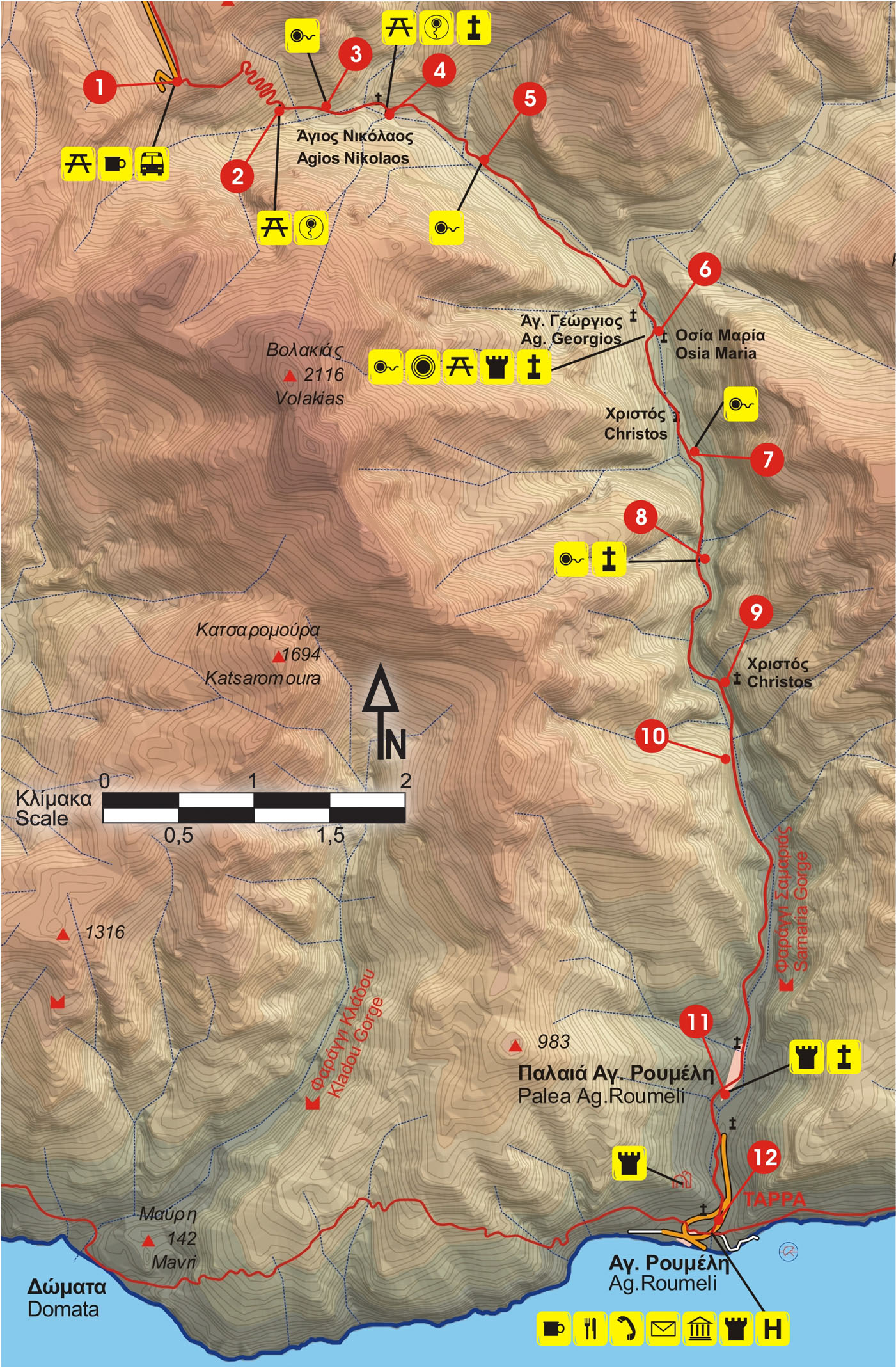
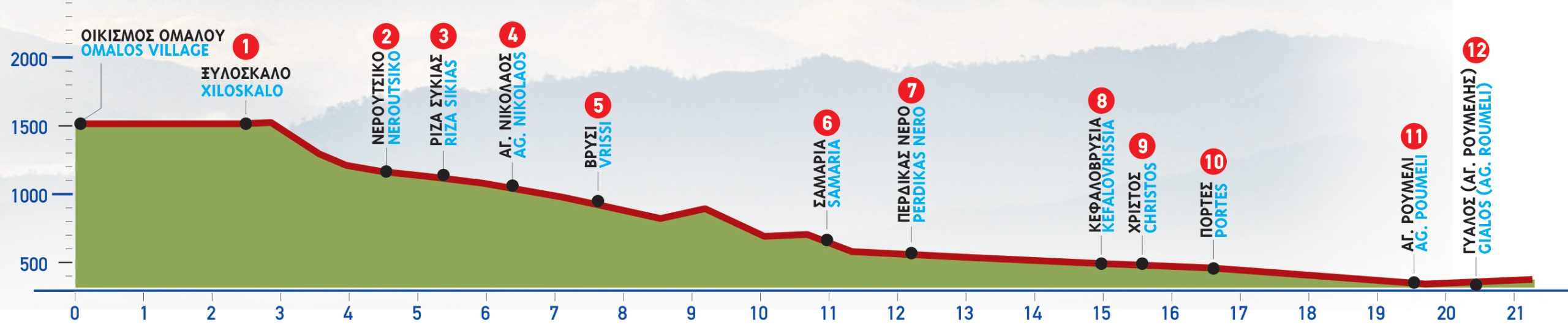
From the area of Xiloskalo, from an altitude of 1.200 m, we can enjoy, in advance, part of the magnificent route which we are about to follow.
The view of the mountain tops marking the limits of the valley of the gorge is spectacular; to the east rises the slope with the peak where the Kallergis Mountain Shelter is located, as well as the peaks of Psari and Melidaou; to the south, the magnificent peak of Volakias and the “divine” Mount Gigilos, one of the most superb summits of Crete. In the distance, to the east, Pachnes can be seen.
We begin descending towards the steep gorge, following the very well-defined but also very precipitous path.
After approximately 40 minutes, having walked for about 1.900 m, we arrive at Neroutsiko, where we find a designated rest area. We continue for about another 1.000 m and then we come to the water spring Riza Sikias to our left.
After Neroutsiko, the path becomes less steep. At first, the stream is on our right-hand side, but after a certain point we follow its bed; this is repeated many times until Agia Roumeli, which is why going through the gorge is dangerous during periods when sudden rainfalls can create floods. For this reason, passing through the gorge is only allowed from May 1st to October 31st.
About 25 minutes from Rίza Sikias, the first water course, we notice the ruins of the base of a structure, where a water-powered saw mill for timber was once installed. We continue for approximately another 10 minutes. 1 km in total from Riza Sikias, we reach the centre of a small flat area with huge cypress trees, where there are the chapel of Agios Nikolaos, the guardhouse of the Forest Authority and a water spring.
This is believed to be a possible location of the ancient town of Keno.
After Agios Nikolaos the trees thicken and the passage becomes narrower. In about 15 minutes, having walked for approximately 800 m, we arrive at Vrisi, where a stone water fountain can be found. Having crossed the stream several times, we leave the water course to our left and continue to go slightly uphill.
By now, on our left-hand side, to the north, the peaks of Melidaou and Psari, as well as the gorge of Kalokampos in between them, can be seen.
Up above Kalokampos we can distinguish an old tower. As soon as the path begins to descend, it meanderson the slope until the stream at Kolardaktis. On the hill to the south, there is a chapel of Agios Georgios and a huge cypress tree.
Having passed a sharp right turn of the path, we see the settlement of Samaria. We arrive there after walking for a while in the stream bed and having come out onto its right-hand side, below the hill, where the chapel of Agios Georgios is located. An old olive grove can be seen at the foot of the hill, next to the path.
About 3 km after Vrisi, leaving our main route, we cross a small bridge at the square of the abandoned settlement of Samaria. At this point there is a designated rest area, a guardhouse of the Forest Authority and drinking water.
We leave the settlement of Samaria, cross the bridge and, taking a southerly direction, we immediately come to a narrow passage between a vertical rock and the bank of the stream, where the ruins of a building are distinguished.
Immediately after the narrowing, in a niche, there is a chapel dedicated to Christ (Christos). A few metres further on, we can see the makeshift helipad which is used in case of an emergency.
If we turn left, bypassing the helipad, we will descend to the stream bed. Opposite, on the eastern bank, the ruins of the houses of Kato Chorio of Samaria can be distinguished. From the settlement, we climb slightly for a while and then we encounter a chapel of Osia Maria, to which Samaria owes its name (in Greek: Osίa = minor Saint).
We return to the helipad, and leaving it on our right-hand side, we follow the path in a southerly direction. A little further on, we meet a small bridge by which we cross to the eastern bank of the stream. Approximately 1 km from the settlement of Samaria, we reach a water spring called Tis Pérdikas to Neró (= water of the partridge).
We then pass a narrow section of the gorge, where we see the ruins of a water-powered saw mill, and we continue for a few minutes descending to the stream, to a certain point where the gorge walls rise vertically. The path by now is indistinct, but we, in any case, follow the stream.
When we reach a scree area, the path crosses to the eastern bank, until the area named Kefalovrisia. One can see huge plane trees in the stream, from the roots of which waters spring. Tradition has it that these springs used to supply the shrine of the Oracle of Apollo which existed in the region.
Continuing from Kefalovrίsia, we follow the path on the eastern side of the gorge.
The spring waters from Kefalovrisia run throughout the year.
A little further on, we pass by an old ruined water mill; having walked past it, we reach the chapel of Christos, in a flat, forested area on our left. We next meet Portes, the “gates” to the gorge.
By now, we are in the most spectacular section of the gorge, where the narrow passages with the vertical walls succeed one another. We must be careful because rocks sometimes fall from above, especially in the late evening and early morning hours, when wild goats roam about, on the precipitous gorge walls. This inaccessible, steep area is the kingdom of the Cretan wild goat (kri-kri).
Leaving this impressive passage behind us, the landscape becomes more even. The stream bed begins to widen. Still on the path, we encounter the guardhouse of the Forest Authority and then the old settlement of Agia Roumeli.
We firstly reach a neighbourhood named Spilia, then Mesogitonia and, having continued for a little while on the western bank of the stream, we arrive at Kato Gitonia, which is situated on its eastern bank.
Furtherdown, wepassbya small bridge, exactly where a church of Agia Triada is to be found. We then pass by the courtyard of the church, where the old graveyard of the settlement used to be, and continue towards the outlet of the gorge. Having crossed the stream one more time, we reach its western bank and we can see the coastal settlement of Agia Roumeli.
On the top of the hill to our right, a half-ruined fortress can be seen. On the bank of the stream, to our right, there are the relics of an old water mill and in the stream bed, an old stone bridge lies in ruins.
We continue on our right-hand side. We encounter a church dedicated to the Dormition of the Virgin, built on the site of the ancient temple of Apollo.
After 18 km of walking in one of the most impressive gorges of Europe and surely the most magnificent of Crete, we come to a point where we gaze upon the endless blue of the Libyan Sea.
None
6 hours & 30 minutes
18000m
From May to October only


For the Rural Greece accessibility is fundamental to enhancing an inclusive tourism experience. Following the principles of inclusion and equality, the epaithros Rural Tourism Network and its member businesses are constantly working to enhance the tourism services provided, ensuring that all visitors have the opportunity to experience the authentic beauty of the Greek countryside.
Sustainability in tourism refers to a way of developing tourism that respects and protects the environment while strengthening the local economy and preserving cultural traditions. The aim of sustainable tourism is to provide unique and authentic experiences for visitors without harming the natural and social environment, while ensuring that local communities benefit from tourism activity.
This type of tourism is based on three pillars:
With sustainable tourism, visitors can have authentic experiences, knowing that the impact of tourism on the region is positive and lasting for future generations.
For Rural Greece, localism is one of the most important factors for the development of sustainable tourism, as it promotes a strong link between the tourism product and the local society, economy and culture. Through localism, visitors get the opportunity to explore authentic elements of the destination, such as local products, traditions and culture. This not only boosts the local economy, but also helps to sustain and strengthen local businesses, creating new jobs and supporting the development of local communities.
Furthermore, localism contributes to the sustainability of the tourism sector, as it reduces the use of resources from other regions and encourages the use of local goods and services, reducing the ecological footprint of tourism activities. Thus, integrating localism into tourism practices enhances sustainability awareness, both among visitors and local businesses, creating a more responsible and sustainable tourism destination.